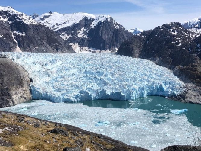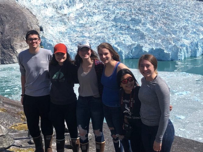
Petersburg High School students had an easier time this year surveying the position of the LeConte Glacier near Petersburg. A team of six students continued the tradition of recording the annual location of the glacier’s face dating back to 1983.
Every spring for the past 36 years, a select team of students has enjoyed a pretty amazing and probably unique high school field trip. The sole senior on the team this year, Gillian Wittstock, was the only student who also made the trip last year.
“It went a lot quicker this year because last year the south side unfortunately had a very big calving occur right after they finished all their points so they had to redo almost all of them,” Wittstock explained. “And so that took a bit time. This time I was on the south side and we were very lucky and there were no major calves and so we were able to get all of our points, head over in the helicopter and help them out with getting their points. It all went really smoothly. It was really simple, so it was good everything went great and it was a pretty quick trip.”
For the survey work, the students are split into in two teams. One team is helicoptered into the south side of the steep mainland fjord, sights their points and then joins the other team on the north side. That north side team has some time to relax waiting for the other team to fly over. But after that sophomore Leesa Murph explained it’s kind of a time crunch.
“When they come over we’re like in rush mode because if the glacier calves and their points fall off with it, then we’ve lost those points and we can’t go back and get the points they’ve lost exactly, so we’re kind of rushing through that,” Murph said.
The teams only lost a couple of points to that calving, when blocks of ice sometimes the size of city buildings drop from the face into the water. LeConte is the southernmost tidewater glacier in the northern hemisphere. And it’s been studied for that dynamic interaction between the relatively warmer ocean water and colder meltwater from the ice. This student science project has recorded massive retreats and some advances to add to that research. High school science teacher Victor Trautman has been leading this student survey project for over two decades.
“It was surprising,” Trautman said of this year’s trip. “There wasn’t a lot of really big ice in the fjord but a lot of small stuff. Well small, you know, the size of a house, size of a bus, nothing the size of a school house. So there was only a few big chunks in there. So I think it’s really crumbly.”
Trautman took over the program from its founder and former teacher Paul Bowen. And he could be passing it on to math teacher Tommy Thompson as Trautman plans to retire this year.
Both teachers are with the students a science classroom at the high school on a Friday evening, May 10, the same day as the survey trip. They’re reviewing the geometry and trigonometry needed to translate the angles they recorded to positions on the face of the glacier.
Junior Jack Byrer has been on the survey team for two years but like most of the other students it was his first survey trip out to the glacier. He described the helicopter ride up to the survey spots.
“As soon as you do it, it’s just easy, there’s no kinks really and once you get in, you get to breath for a minute and then as soon as he takes off you know you’re fine,” Byrer said. “You just to look and enjoy the view and it’s just incredible and especially with the glacier you get to see all the great stuff. We saw some mountain goats on our way there and we saw tons of seals on our way back that were all sitting on the ice. It was just incredible. And as we were going out, he took a little scenic route. He went right in front of the glacier, gave us a good photo opportunity.”
The pilot is Wally O’Brocta of Temsco Helicopters. It’s not just a fun trip to the glacier. Students on the team, this year one senior, four juniors and one sophomore met every Wednesday at lunchtime during the school year to practice surveying points. But the students involved all say the trip made that effort worth it.
“It is so pretty over there especially when it’s really sunny,” said junior Jolyn Toyomura. “We started off on the south side so it was kind of chilly but when we went to the north side it was burning.”
“It’s really fun,” agreed classmate Maddy Whitethorn. “It’s kind of hard to actually believe that this is where we live and we have opportunities like this. So I’m just really thankful for all the resources we have in our community to do things like this.”
Another junior Maria Pfundt explained it’s not as competitive to get into the glacier trip as you’d think.
“I feel like not enough students really realize what it is and the experience it is,” Pfundt said. “So if you take the geology survey class and you take more advanced math classes and you want to be a part of it, most likely they’ll find a way for you to be a part of it. But there is a certain amount of commitment that has to go with it so that the students that do come actually want to be there for the specific purpose of the glacier.”
Students documented a small advance of the glacier’s terminus this year, averaging about 60 feet from last year’s position. 2018 saw a retreat of the terminus, so this small advance puts it in a similar position as measured by the 2017 team.
